
On Friday, Grand Rapids officially (at the Ford Airport) had a daily record with 9.2″ of new snow. That was a record for November 29. The old daily record was 4.5″ on November 29, 1960. Because some of the snow melted and some settled, we didn’t have a 9″ snow cover. The airport reported 5″ on the ground early Saturday morning (11/30).
Grand Rapids added another 1.5″ of snow on Saturday, giving us 10.7″ in two days and 11.3″ for the month. In November, we had 17 days with 10% or less of possible sunshine and only 2 days with more than 75% sunshine.
It was the snowiest single day EVER at the National Weather Service site 9 miles south-southwest of Gaylord in Lower Michigan.
SNOW             9 SSW GAYLORD           44.91N 84.74W
11/30/2024  M24.8 INCH  OTSEGO COUNTY MI   OFFICIAL NWS OBSERVATION

            24 HOUR SNOWFALL TOTAL FOR THE CALENDAR DATE
            OF NOVEMBER 29TH, 2024. THIS MARKS THE
            SINGLE SNOWIEST CALENDAR DATE EVER FOR GAYLORD,
            SHATTERING THE PREVIOUS RECORD OF 17.0
            INCHES, ORIGINALLY SET ON MARCH 9TH, 1942.

AND...look at the snow they had a Sault Ste. Marie:

SNOW             2 E SAULT STE. MARIE    46.48N 84.32W
11/30/2024  M15.7 INCH       CHIPPEWA MI   OFFICIAL NWS OBSERVATION

            24 HOUR TOTAL FOR THE CALENDAR DATE OF
            NOVEMBER 29TH, 2024. THIS MARKS THE 6TH
            SNOWIEST CALENDAR DATE ON RECORD FOR SAULT
            STE. MARIE. THE STANDING RECORD OF 26.6
            INCHES OBSERVED ON DECEMBER 10TH, 1995
            REMAINS INTACT.

The Festival of Lights in Sault Ste. Marie was canceled because of the snow and rescheduled for Friday, December 6.
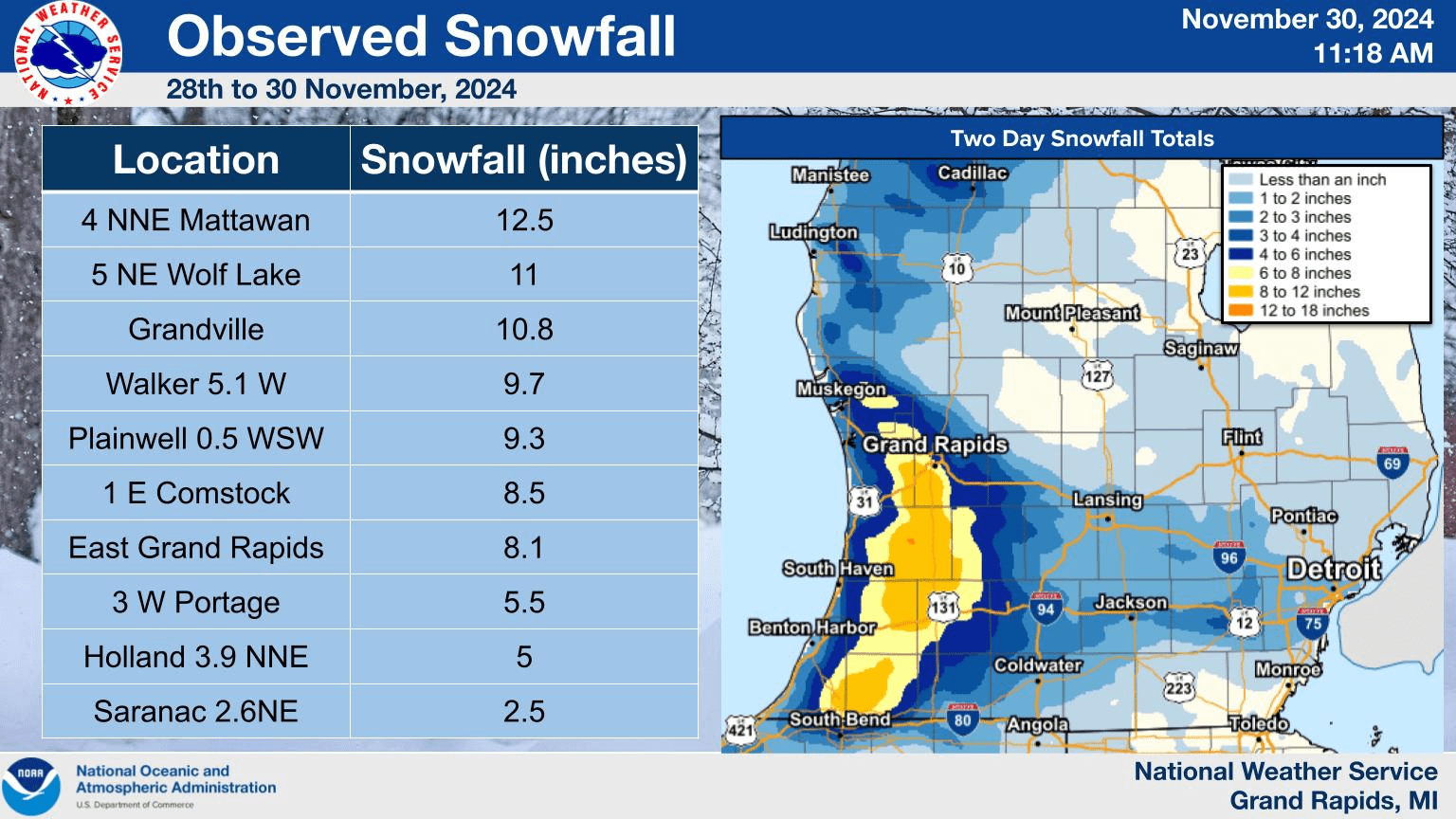
SNOWFALL: 20″ east of Sault Ste. Marie, 14″ Darrah, 13.2″ Mancelona, 13″ Bridgeton, 12.9″ Waters, 12.5″ Mattawan and Rapid City, 11″ Grandville, 10.8″ Wolf Lake,
Grand Rapids (airport) 10.7″, Grandville 9.9″, Walker 9.7″, Plainwell 9.3″, Otsego Lake State Park, 9.2″ Lovells and Comstock, 8.1″, Paw Paw and Jamestown, 7.6″ Allendale, 7.0 Kalamazoo, 6.5″, Elmira, 6.5″, Walker,
6.0″ Kingsley and near Traverse City, 5.9″ Caledonia, 5.0″, Holland 4.1″, Marne, 4.0″ Dalton, 1.7″ Muskegon, 0.8″ Lansing (note the Lower totals at Lake Michigan and east toward Lansing with the heavier amounts along US 131 inland).
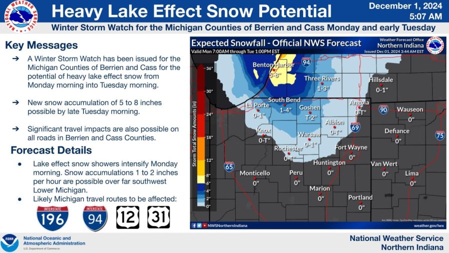
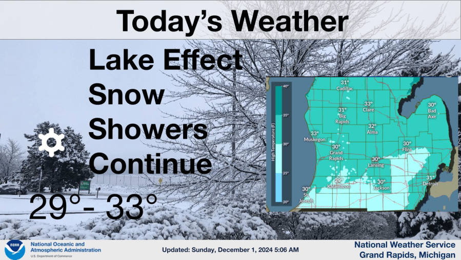
Periods of snow or snow flurries are possible today (Sunday).
The temperatures should be below freezing all for most of this Sunday, which means the snow may sticking to untreated roads, and especially sidewalks, driveways, parking lots and lesser traveled roads. Heavier snow showers can cause roads to ice up quickly. If you are driving, the road might be just wet and then you drive into a heavier snow band or an untreated section of roadway, the road gets slick quickly.
Grand Rapids has had 11.4″ of new snow in the last 3 days. Light, fluffy snow tends to settle Sunday morning Grand Rapids was down to 3″ of snow on the ground.
Here’s live radar for Ottawa, Kent, Ionia and Montcalm Counties

Southern Lower Michigan radar

State of Michigan radar

Midwest radar

National radar
Here’s current Michigan weather observations, a surface weather map and the latest Grand Rapids NWS Forecast Discussion.
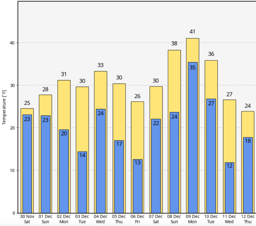
The cool weather pattern will continue at least into the 2nd week of December. Here’s the forecast high and low temperatures from the Friday night run of the European model. For the next 15 days, the warmest day is a high of 41 and the lowest is 13 above.
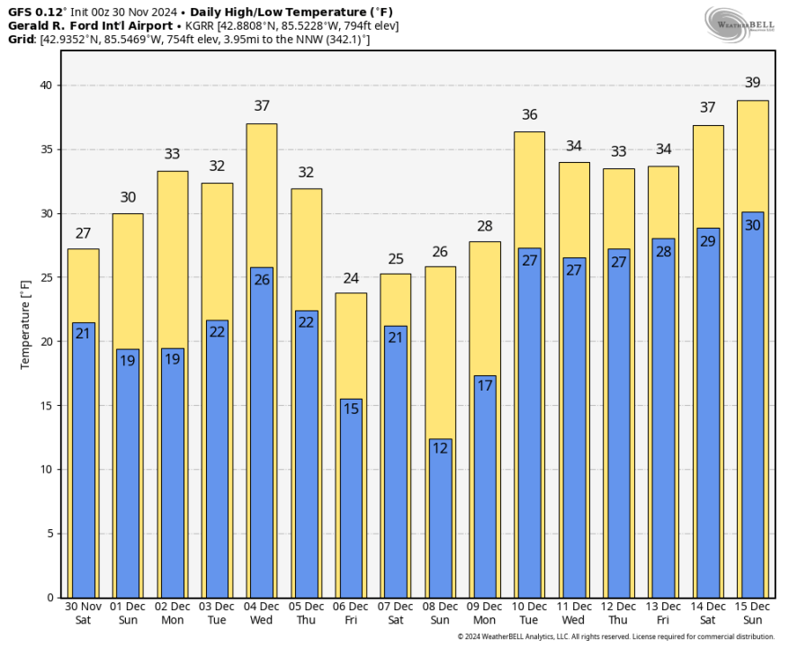
Here’s the forecast highs and lows for Grand Rapids from the Friday night run of the GFS model. It continues the cool pattern through the 2nd week of December with a forecast low temperature of 12 on December 8.
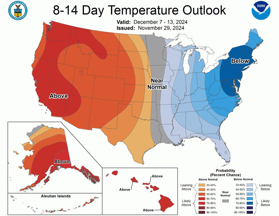
The latest 8-14 Day Temperature Outlook calls for a continuation of below average temperatures in the Great Lakes and Northeast, with warmer than average temperatures in the West and High Plains.
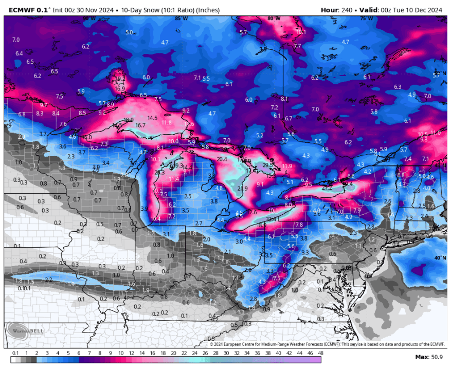
The map above is forecast total snowfall over the next 10 days from the European model. Note the heavier lake-effect snow downwind from all five of the Great Lakes plus Lake Nipigon (north of Lake Superior), Lake Champlain (northwest Vermont) and James Bay (at the top of the map). You can also see the heavier snow in the mountains (higher elevations of West Virginia.
Ski Brule has once again been the first ski resort in Michigan to open. They reported, “Olympic Gold Medalist Nick Baumgarter joined us at opening for the first chair.”
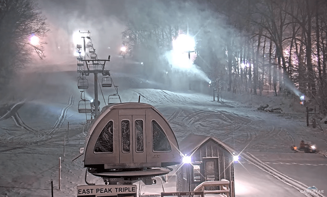
This is a screen grab from one of the webcams at Caberfae Ski Resort – early morning of Saturday, November 30. The snow guns were running and natural snow was falling. They expect to open on December 7 and they should have plenty of snow by then.

This pic. from Sugar Island is from Jim Lehocky and the Gaylord NWS facebook page. That’s a lot of snow!
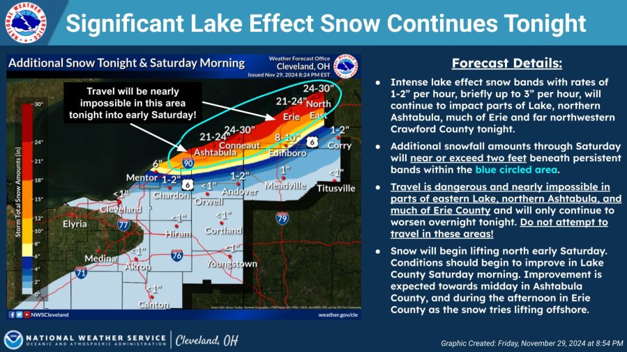
Up to 30″ of lake-effect snow has caused authorities to close I-90 from NE of Cleveland OH to near Buffalo NY: “Due to the lake effect snow storm and the closure of I-90 in PA from the NY State line to I-79, ALL VEHICLES are banned on the Thruway (I-90) …until further notice. People are reported to be stuck in their cars.

Pic. from NITTEC of I-90 near Ripley, New York
The heaviest lake-effect snow band has stayed just south of Buffalo. The San Francisco 49ers/Buffalo Bills NFL game is Sunday evening (on WOOD TV8). If the band were to by chance come farther north, heavy snow could fall at Highmark Stadium. The stadium is several miles south of the Buffalo Airport (BUF).
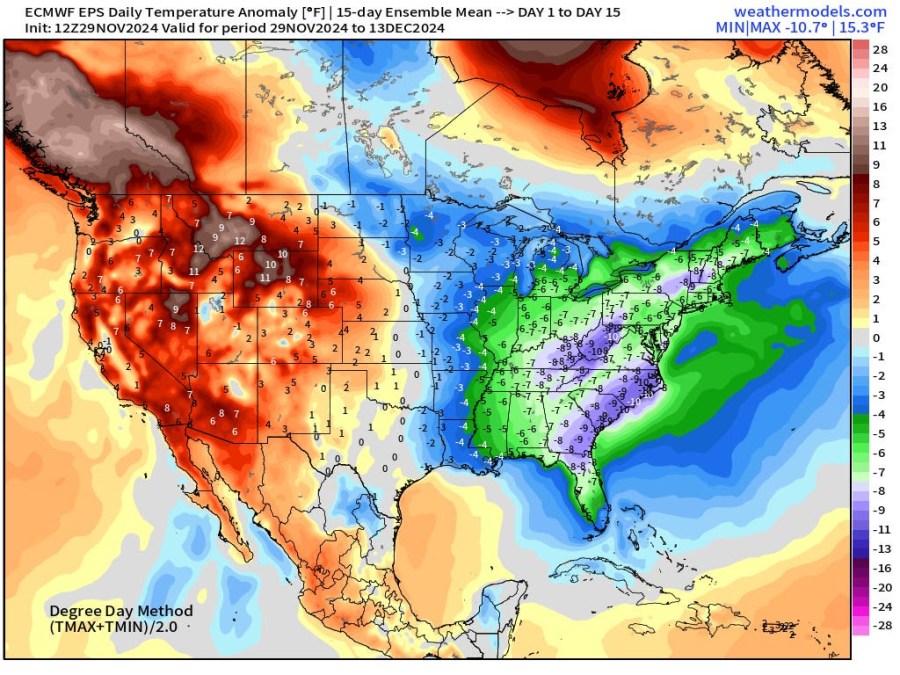
Here’s the forecast temperature anomaly (differencefrom average) over the next 15 days. We’re forecast to be 3-6 degrees cooler than average in West Michigan. Note the general pattern – cooler than average in the eastern half of the U.S. and warmer than average in the West.


