
The answer to the question is “yes”, but the question should be WHEN will it snow. It’s possible (not a sure thing) that we could see our first snowflakes in West Michigan later this week. We do know that a pattern change will bring colder air to West Michigan and much of the eastern U.S. starting Wednesday night.
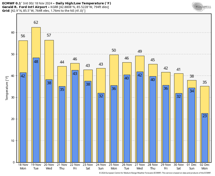
Here’s forecast high and low temperatures from the overnight model run of the European model. We have 3 mild days coming for Monday, Tuesday and Wednesday. The colder air arrives Wednesday night and temperatures after that will remain in the mid 40s during the afternoon for the 2nd half of the week.
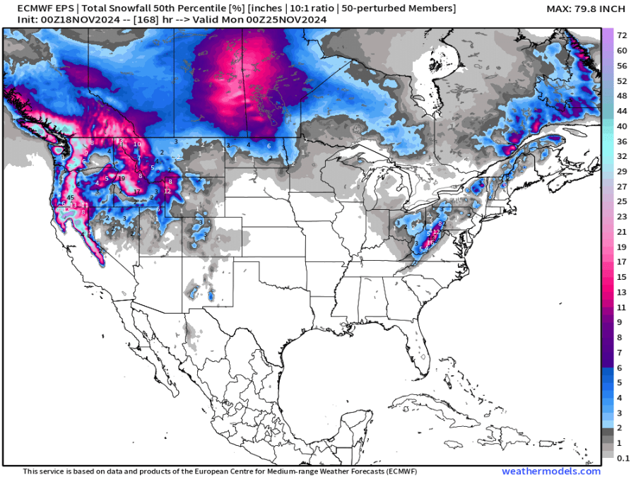
This is the European model overnight run showing forecast snow over the next 7 days. The model does give some light snow (less than an inch) to areas inland from Lake Michigan. The most likely time for some mixed snow would be Wed. night into early Thursday. The snow would likely melt fairly quickly, especially on pavement.
Last year, West Michigan’s first snowflakes fell on Halloween
Lake Michigan water temperatures are still relatively warm, so that could keep the precipitation more a cold rain close to the lake. Gale Warnings will be in effect from 10 pm this Monday evening until noon on Tuesday for gusts up to 30-40 mph. Waves will only be 1-3 feet nearshore because winds will be mainly southeast, coming off the land.
In the meantime, we’re mild this Tuesday with a period or two of rain…The high temperature will reach the low 60s Tuesday afternoon. Average high temperatures now are in the mid-upper 40s.
We saw a brief period of sunshine Mondaay, but the overall cloudy pattern will continue. From Nov. 14-17, we had a total of 7 minutes of sunshine. We’ve had 10 days this month with less than 10% of possible sunshine and only 3 days with more than 55% of possible sunshine.
Side note: The NWS forecast discussion for West Virginia says: “Snow accumulations of a couple of inches are likely across the higher elevations of southeast West Virginia.” This would be in the Thursday-Saturday time frame.
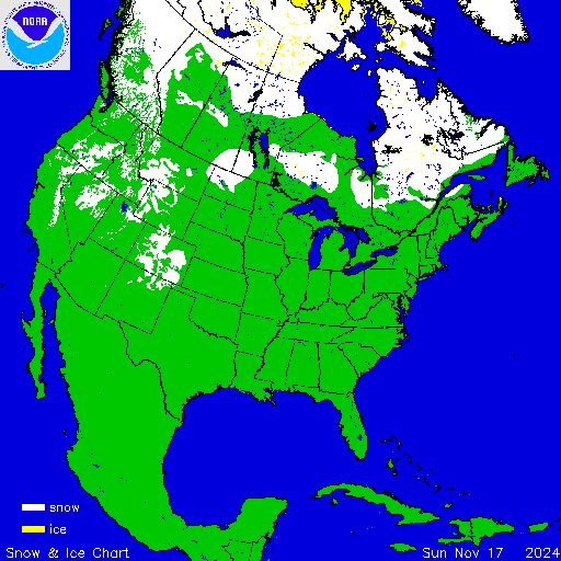
Here’s North American snow and ice cover. You can see the snow in the mountains out West an there is snow north of Lake Nipigon in Ontario.
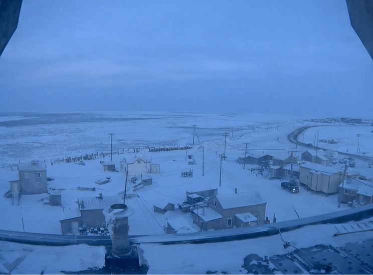
This is a webcam from Utqiagvik, Alaska (formerly Barrow). This is the land of the midnight sun in summer and the noontime dark in winter. The sun is setting there, so the best available light here in late November is twilight. Ice is quickly forming along the shore. The high temperature here Sunday was +3°. The warmest temperature this month at Utqiagvik has been 25°. It’s also a windy place – the average wind speed so far this month has been 18.3 mph with the fastest gust at 49 mph. The wind has been blowing from the northeast off the ocean almost every day this month.
Anchorage has 12″ of snow on the ground with 10″ at Northway. Arctic Village dipped to -17° Sunday morning. Anchorage has already had 26.5″ of snow this winter, more than double the average. The nearby Alyeska Ski Area reports a season snowfall total of 98″ at the top of the mountain with 44″ of snow on the ground.
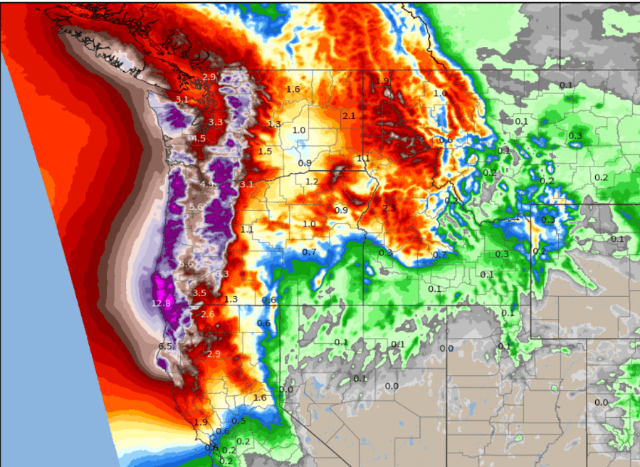
A “bomb” cyclone (low pressure center) off the Pacific Northwest coast will send an “atmospheric river” of moisture into western WA and OR, where there will be heavy rain totals and significant mountain snows. A Winter Storm Warning is in effect for the Cascade Mountains for up to a foot of new snow. The map above shows forecast total rainfall over the next week.


