GRAND RAPIDS, Mich. (WOOD) — Seasonal outlooks are inherently tricky, but oceanic and atmospheric signals across the globe can help to paint how our winter season might lean.
Things like water temperatures south of Alaska, snowpack in the northern hemisphere or water temperature differences off the coast of South America all have been proven to play a role in how storm tracks behave over West Michigan.
WEAK LA NINA
Meteorologists predict the upcoming winter will bring a “weak” La Nina pattern. A La Nina pattern is a part of the ENSO (El Nino Southern Oscillation) cycle. A La Nina phase occurs when water temperatures in the equatorial Pacific off the coast of South America are cooler than normal.
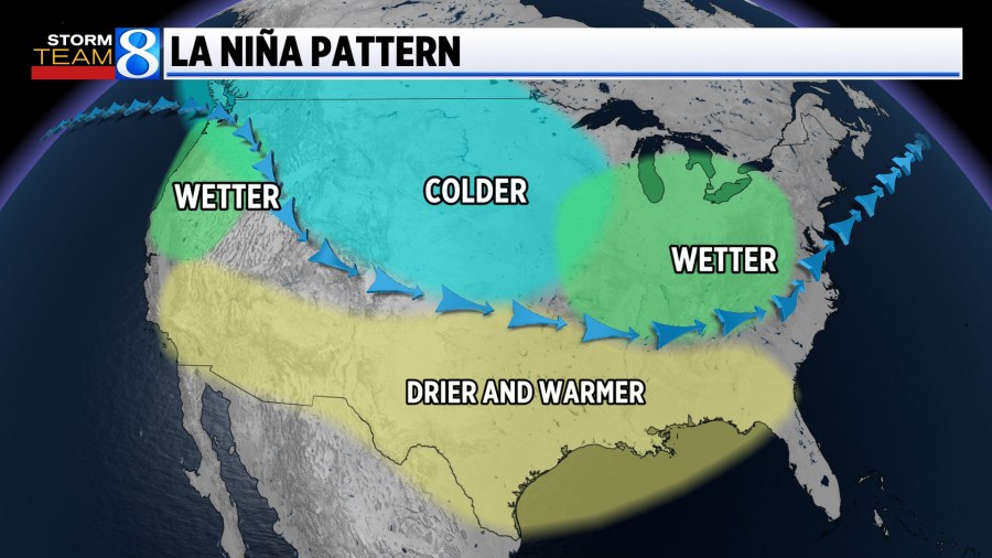
When a La Nina occurs, the jet stream over the United States is pushed northward. This typically results in a colder and wetter winter (in the form of either rain or snow) for the Great Lakes and Pacific Northwest. Meanwhile, the southern United States typically trends warmer and drier.
Weak La Nina winters in the past have produced a wide range of snow totals in West Michigan.
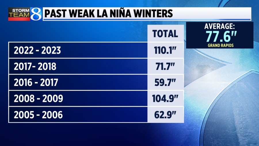
Last year, the globe was in an El Nino phase. This is when the equatorial pacific waters are warmer than normal. As a reminder, last winter only brought 47.5 inches of snow to Grand Rapids. That’s around 30 inches below average.
The weak La Nina pattern has Storm Team 8 hopeful we will see closer to average snowfall totals, which may seem like a lot following last year’s shortages.
WHAT ABOUT THE POLAR VORTEX?
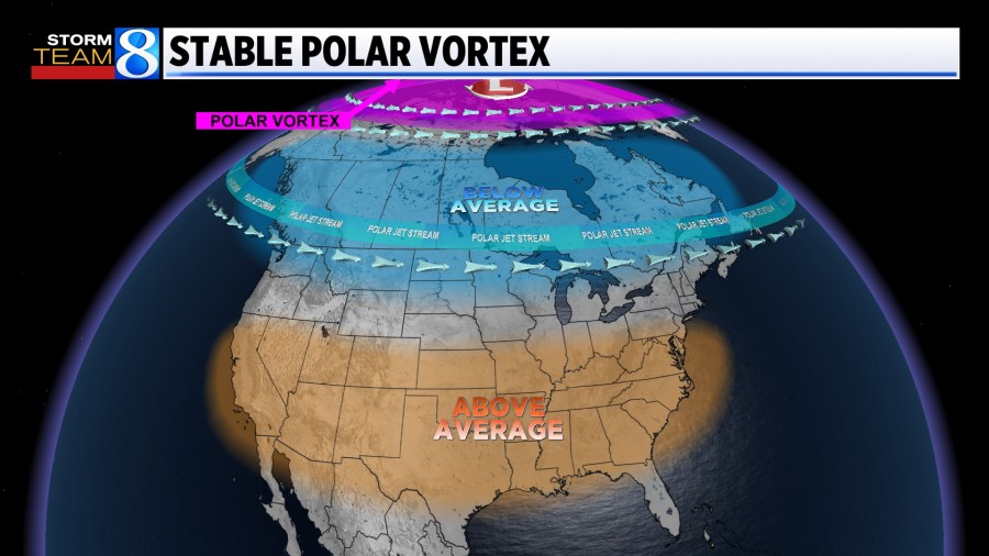
The polar vortex can follow one of two modes during the winter. The stable phase traps cold air close to the north pole. The disrupted phase allows cold air outbreaks to spill suddenly into lower latitudes, like West Michigan.
La Nina years, like the one we are experiencing, have been linked to more disrupted polar vortex patterns. When the polar vortex pattern is disrupted, our jet stream takes on a wavy appearance and frequently delivers big temperature swings.
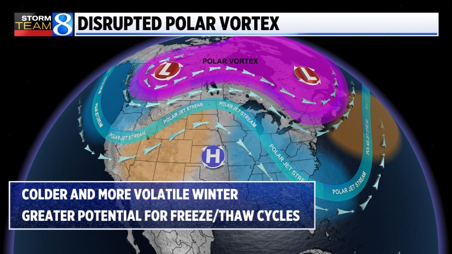
The link between La Nina and the polar vortex pattern will set the stage for a healthy lake-effect snow season this year, but snow that falls during the cold air outbreaks might be quick to disappear with expected warm swings.
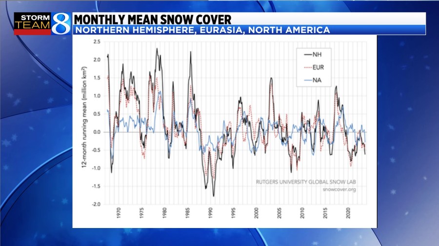
CURRENT NORTHERN HEMISPHERE SNOW
Watching snowpack trends across North America, particularly over portions of northern Asia and Europe, can help to show how fast the winter season will begin in the Great Lakes. Right now, snowpack in those areas is down, which typically leads to a slower start to winter in the Midwest.
Once the cold air in Asia and Europe forms, however, it can lead to a fast and hard transition to winter in Michigan.
Michigan typically sees around a half an inch of snow in October and about a half a foot through November.
Warmer-than-usual Lake Michigan water temperatures will also help delay accumulating snow to at least late November, but when the flip to winter starts, we expect it to be fast and strong.
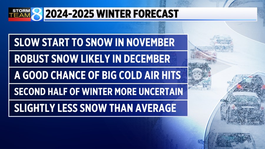
STORM TEAM 8 OUTLOOK
Identifying patterns is only half the battle when it comes to winter forecasting. Anticipating how all these signals of various strengths, time scales and spatial scales will work together can be difficult. Even more so when Lake Michigan and lake-effect snow are factored in.
We’ve seen lake-effect snow events drop 2 inches on some communities and 2 feet on others. Lake Michigan’s snow potential makes exact snowfall amounts very difficult to pin down.
Still, each member of Storm Team 8 has submitted their guess for the season. You can enter your best guess, too, for a chance to win $250 and to beat Storm Team 8.
As you make your forecast, here are the biggest trends we are expecting based on the signals and patterns appearing across the world:
Remember to stay with Storm Team 8 this winter. Blake Harms will be issuing his seasonal School Closing Predictions before each snow. Every Thursday in the Snow Conditions Report, Matt Kirkwood will compile the best one-stop spot to check on snow totals across the state for those looking to head out and enjoy.