GRAND RAPIDS, Mich. (WOOD) — A seasonably mild and partially sunny Sunday is ahead for West Michigan.
TODAY Partly cloudy, mild
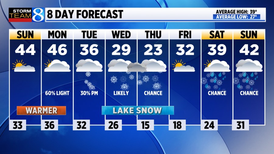
LOW 33°
HIGH 50°
WIND SW 5-10 mph
TODAY Periods of sunshine are expected, with a light southwest breeze and highs approaching 50°.
TONIGHT Light rain showers are likely, especially south and east of Grand Rapids, with lows in the mid 30s.
MONDAY Drizzle & light rain showers are most likely in the morning, before drying out in the afternoon with some sunshine becoming possible. Rain accumulations will be at about a tenth of an inch or less. It will be the warmest day in the near future, with highs reaching the mid-upper 40s.
TUESDAY Colder air is going to begin pouring in, with temperatures sliding into the lower 30s through the day. The lake-effect machine may get going as early as Tuesday evening.
WEDNESDAY Lake-effect is likely, and heavy snow is possible in spots, as high temperatures may fall short of 20°.
LOOKING AHEAD Heavy snow remains possible through late Thursday, and heavy totals will be possible. Thursday will be frigid, with daytime highs likely in the teens, before a warm-up arrives by next weekend.