Grand Rapids had its first sub-freezing temperature of the fall season on Sunday morning. You can read more from Storm Team 8 Meteorologist Scott Larson here.
TODAY: Lots of sunshine today filtered with high clouds
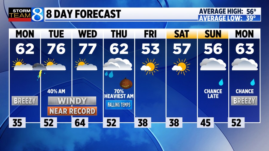
LOW: 35°
HIGH: 62°
WIND: S-SE increasing 10-20 mph
TODAY: Some high-level cloud cover, but mostly sunny overall. A light breeze from the SSE will pick up this afternoon nudging temperatures just past 60 degrees. Fine fall weather.
TONIGHT: Increasing clouds with showers and even a thunderstorm possible just past midnight. Lows drop near 50 degrees.
TUESDAY: Any showers will exit around daybreak or shortly after. Once again mid and high clouds will be a fixture in the sky, but warm with highs topping off near daily records in the middle to upper 70s. The wind strengthens with gusts exceeding 30 mph from the SSW.
WEDNESDAY: Staying windy and very warm. Temperatures hold steady in the middle to upper 70s even with mostly cloudy conditions. Gusts may reach 40 mph.
LOOKING AHEAD: Halloween brings a good likelihood of rain with a cold front cutting through. Much of the rain should be contained to the morning hours with conditions looking OK by the time we get to the evening. Anticipate mostly cloudy skies and temperatures in the middle to upper 40s for trick-or-treating with a small chance of drizzle or a few sprinkles.
Highs are likely to stick in the 50s for much of the extended forecast with another rain chance organizing next Sunday.