GRAND RAPIDS, Mich. (WOOD) — West Michigan’s first snowfall is likely, at least for some, Wednesday night.
TODAY Falling temps, morning rain, evening mix
MORNING 44°
AFTERNOON 42°
WIND NW 10-20 mph
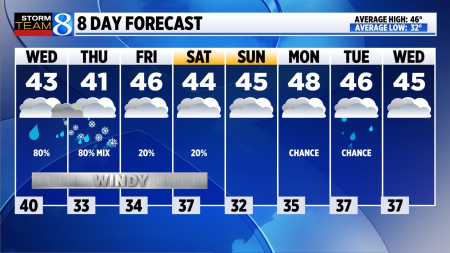
TODAY A batch of rain showers are expected into late morning. After a dry period for part of the afternoon, additional showers are expected to develop, and through the evening some will begin to mix with snow. This comes as temperatures fall through the day, from the mid 40s in the morning down to the upper 30s by evening. Winds will gust to 30 mph out of the northwest.
TONIGHT A mix of rain and snow is expected, with rain most likely along the lakeshore and snow most likely inland. Slushy accumulations, mainly on grassy surfaces, are expected in those areas with lows near freezing.
THURSDAY The rain / snow mix is expected to persist through at least the morning, possibly into part of the afternoon, with the lakeshore most likely to see rain. Additional light, slushy accumulations on grassy surfaces will be possible inland. It will be the coolest day of the week, with highs only in the low 40s. The slush or snow will melt off quickly into the afternoon.
FRIDAY A few light rain showers are possible, with cloudy skies, highs in the mid 40s, and gusty northwest winds.
WEEKEND A few showers linger into Saturday, though most of the day looks rather dry. Temperatures warm to the mid 40s under cloudy skies. Winds will die down by late afternoon.
LOOKING AHEAD High temperatures will remain in the 40s into next week, with a few more chances for precipitation.
View the Storm Team 8 2024-25 Winter Outlook here