GRAND RAPIDS, Mich. (WOOD) — If you are lucky enough to catch a glimpse of sunshine after the fog this morning soak it in. Clouds will move in quickly today and sunshine will be rare in the week ahead.
TODAY Showers and Clouds
LOW 38°
HIGH 56°
WIND E 5-10 mph
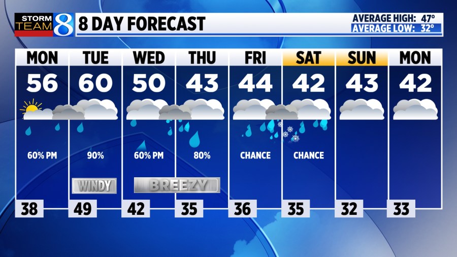
MONDAY Rain will roll in from southwest to northeast through the afternoon and evening. Areas south of I-94 will be the first to see rain with areas north of I-96 likely staying dry until the evening commute. Rain showers will be light, along with the wind. Highs will climb to the mid-50s.
TONIGHT A few rounds of rain will move through with some steady downpours possible. Thunder is not expected. Lows will be mild, hovering near 50 degrees.
TUESDAY Rain is likely, especially early in the day. Expect mild, cloudy, and blustery conditions in the afternoon with a few lingering showers. Highs will reach near 60 degrees with winds out of the southeast at 10-20 mph, gusting to near 30 mph at times.
WEDNESDAY Scattered showers continue, especially near and south of I-96. Most of the rain will fall in the afternoon and evening. Temperatures will begin to cool with highs near 50. A breezy northwest wind settles in and carries through the end of the week.
LOOKING AHEAD Rain showers continue into the Thursday and Friday time frame as temperatures cool into the 40s. Cold air on Thursday and again Friday night might be enough for a few sloppy snowflakes mixing in with the rain. Accumulation is not expected at this point. Stay tuned for updates.
Wanna win $250? Click here to place your guess as to how much snow we will see this winter season. It’s fun, free, and easy to play.


