GRAND RAPIDS, Mich. (WOOD) — A soaking round of rain for the morning will be followed by afternoon drizzle and breezy conditions across West Michigan.
TODAY Mostly Cloudy and Windy
LOW 38°
HIGH 56°
WIND E 5-10 mph
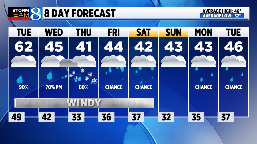
TODAY While the steady rain has come to an end, light showers & occasional drizzle remain possible through the afternoon. It will be mostly cloudy and breezy, with gusts up to 30 mph. It will be mild, with highs climbing into the lower and middle 60s.
TONIGHT Drizzle remains possible as a cold front passes through. Late evening temperatures in the lower 50s will tumble after the front passes, down into the mid 40s by early morning.
WEDNESDAY Occasional drizzle / light rain showers are expected, as temperatures fall into the mid 40s by late afternoon. It will remain cloudy and breezy, with gusts up to 35 mph. Falling temperatures may prime the atmosphere for an eventual transition to snow showers overnight into Thursday morning, with light, slushy accumulations possible in spots.
THURSDAY Slushy snow accumulations are possible by mid-morning, though exact locations and amounts remain uncertain. It will be cool and windy, with highs in the low 40s and winds gusting as high as 45-50 mph. Any snow or mix will melt by the afternoon.
Click here for more in-depth analysis on the active week of weather expected.
LOOKING AHEAD Shower chances linger through Saturday, before likely drying out for the second half of the weekend. Active weather is possible again next week, as highs remain in the 40s.