GRAND RAPIDS, Mich. (WOOD) — Lake-effect snow is expected to pick back up for parts of West Michigan Sunday.
TODAY Lake-effect showers, especially SW of Grand Rapids
LOW 22°
HIGH 30°
WIND WNW 10-15 mph
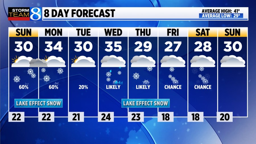
TODAY Lake-effect snow showers are expected once again, this time south of Grand Rapids where a Winter Weather Advisory has been posted for Barry, Calhoun, and Kalamazoo counties through 6 pm. 1-4 inches of snow will be possible, though high temperatures near 30 should keep roadways from becoming too slick. Elsewhere, mostly cloudy skies will persist with a peek of sunshine possible, especially inland.
TONIGHT Heavy lake-effect snow will be possible for a few select communities, most likely south and west of Grand Rapids. Outside of those bands, scattered flurries will be possible with lows in the low 20s.
MONDAY Lake-effect snow will remain possible, especially west of US-131 toward the lakeshore where a Winter Storm Watch is in effect through early Tuesday morning. Grand Rapids appears to be in line for about 1 inch of snow on Monday, but totals may exceed 5 inches as you move southwest in particular where the heaviest totals are favored to stack up. It will be slightly warmer, with highs reaching the low to mid 30s, especially outside of lake-effect.
TUESDAY Perhaps the quietest day of the week. Outside of a few flurries, mostly cloudy skies will continue with highs near 30.
WEDNESDAY A brief warm-up will commence, with highs climbing into the mid 30s due to southwesterly winds. As a clipper system moves through, rain drops may try mixing in with light snow. It will be windy, with gusts to 35 mph.
LOOKING AHEAD Lake-effect snow is expected to flare back up late Wednesday, continuing through Thursday. Strong winds may lead to blowing snow and tricky travel at times. Colder-than-average temperatures are likely to continue through at least next weekend.
Where is Matt Kirkwood? An update on our morning meteorologist