GRAND RAPIDS, Mich. (WOOD) — Heavy lake-effect is expected along the lakeshore, with significant snowfall likely in a few communities.
TODAY Heavy lake-effect snow near the lakeshore
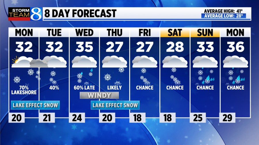
LOW 20°
HIGH 32°
WIND NW 5-15 mph
Winter Storm Warning for Ottawa, Allegan, Van Buren, Berrien, and Cass Counties
Winter Weather Advisory for Kalamazoo, Muskegon and Oceana counties
Check out Meteorologist Blake Harm’s school closing predictions here.
TODAY Heavy lake-effect is expected through the day, especially along the lakeshore in parts of Ottawa, Allegan and Van Buren counties. Snowfall totals by the end of the day could reach double digits in spots. Further inland, flurries are possible with mostly cloudy skies and highs near freezing. Read the latest on this system here.
TONIGHT Heavy snow remains possible overnight, especially south of Holland toward South Haven and Benton Harbor. Another cool night is ahead, with lows chilling down near 20.
TUESDAY Scattered snow showers will be possible in the morning, but activity should gradually diminish through the day. Winds will begin to shift out of the southwest, with highs back near freezing.
WEDNESDAY Strong southwest winds will allow temperatures to warm into the mid 30s. The first half of the day will likely be dry, before light snow / rain moves in late dropping from north to south. Temperatures will fall into Thursday morning, and lake-effect will likely get going again.
THURSDAY Windy and snowy conditions are expected, especially close to the lakeshore as lake-effect intensifies. Several inches will be possible in spots, along with blowing and drifting snow. It will be chilly, with highs in the upper 20s and wind chills in the single digits to lower teens.
LOOKING AHEAD Chances for snow carry into the weekend, although impacts look rather minimal. Drier air begins to prevail with temperatures warming slightly to the mid 30s.
Where is Matt Kirkwood? An update on our morning meteorologist