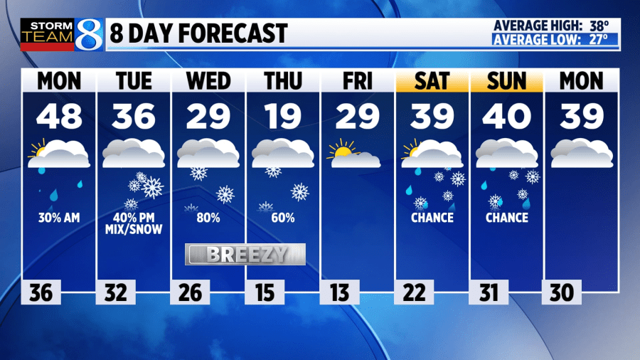
GRAND RAPIDS, Mich. (WOOD) — Opening up the work week with a handful of rain showers. A relatively mild Monday is in store for us with highs returning to the middle and upper 40s.
TODAY Scattered AM Showers, PM Clearing
LOW 36°
HIGH 48°
WIND SW 10-15 mph
TODAY Scattered showers will slide through West Michigan on Monday morning. Accumulations will be light for most at under a tenth of an inch. Some clearing of the skies late in the day. Fairly warm by December standards with temperatures traveling into the middle and upper 40s.
TONIGHT Mostly cloudy. Calm and cool. Lows fall off near the freezing point.
TUESDAY A return to more seasonable winter weather. Highs climb into the middle and upper 30s locally. There’ll be a growing chance of precipitation moving into the second half of the day. An initial mix of rain and snow is possible before a full switch over to snow as colder air snaps in.
WEDNESDAY Lake-effect is likely, and heavy snow is possible in spots, as high temperatures may fall short of 30°.
LOOKING AHEAD Heavy snow remains possible through late Thursday. Thursday will be frigid too, with daytime highs likely falling short of 20°. A warm-up is favored for next weekend.