GRAND RAPIDS, Mich. (WOOD) — Conditions will slowly deteriorate Wednesday. Steady snow is expected to arrive by mid-morning with conditions sharply dropping off around nightfall.
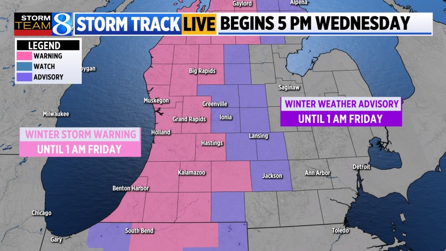
Winter Storm Warning in effect for counties near and west of US-131 until 1 AM Friday.
Winter Weather Advisory in effect for counties east of US-131 until 1 AM Friday.
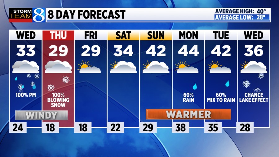
TODAY Cloudy start, widespread snow in evening
LOW 24°
HIGH 33°
WIND SW/NW 15-20 gusting 30-40 mph
TODAY A few quick snow showers are possible early in the day but most of the morning will be dry and chilly. A strong southwest wind will push temperatures into the low 30s this afternoon. Light snow will develop in the afternoon with a few raindrops mixing in. Expect a strong cold front to cut through around nightfall, dropping temperatures quickly with lake-effect snow and winds gusting to 45 mph. The Winter Storm Warning and Winter Weather Advisory go into effect at 5 p.m.
TONIGHT A flash freeze is possible as temperatures tumble and lake-effect snow bands start cranking. Winds will be steady from the northwest at 20-25 mph with gusts near 45 mph. Whiteout conditions are possible with wind chills dropping into the single digits. Road salt will become less effective.
THURSDAY Windy and snowy conditions are expected with several rounds of lake effect through the day. It will be chilly, with highs in the upper 20s and wind chills in the single digits to lower teens. Accumulation will range from 3 inches to 8 inches in the warning area. Blowing and drifting are likely with whiteout conditions expected at times.
FRIDAY Much quieter with some areas of sunshine. Wind will be much lighter, out of the west at 5-10 mph with temperatures near 30.
LOOKING AHEAD It looks to be a mostly dry weekend as temperatures begin to warm to the low to mid 40s early next week. At that point, most precipitation will fall as rain triggering some melting to take shape.