GRAND RAPIDS, Mich. (WOOD) — Cold wind will help to dry things out today, but the stiff breeze will make it feel more like the 20s this afternoon.
Active weather across parts of the nation expected on the busiest travel day of the year.
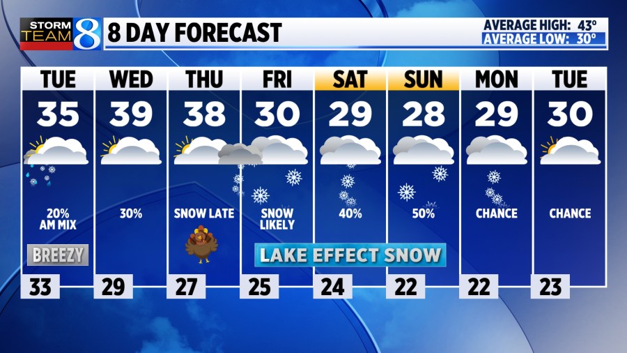
TODAY Chilly, stiff wind and mostly cloudy
LOW 33°
HIGH 35°
WIND W 15-20 G30 mph
TODAY Mostly cloudy and chilly today with a stiff wind out of the west at 15-20 mph. Highs will be in the mid 30s, but with the wind it will feel like the 20s all day. The clouds are expected to break revealing blue sky in the afternoon, especially south of Grand Rapids. Some light lake effect snowflakes or sprinkles are possible north of Grand Rapids, especially after dark.
TONIGHT Wind drops off and temperatures dip below freezing for a quiet and mostly cloudy night.
WEDNESDAY Mostly cloudy skies are expected, along with highs in the upper 30s. It wont be nearly as windy. There is a chance for a light rain or snow mix to form, especially south of I-94 in the afternoon as a system slides south of Michigan. Local impacts appear to be light.
THANKSGIVING Chilly, with morning lows in the upper 20s and areas of light mix possible. Expect afternoon highs in the 30s. It will be mostly dry most of the day, but lake effect snow is expected to begin in the evening with snow after dark might make roads quite slick. Stay with Storm Team 8 for the latest.
LOOKING AHEAD A significant pattern change to colder, and potentially snowy weather looks likely for the end of the week. Lake-effect snow is likely for Black Friday, and at times through the weekend into next week.
Where is Matt Kirkwood? An update on our morning meteorologist
Cold, snow: sharp pattern change ahead