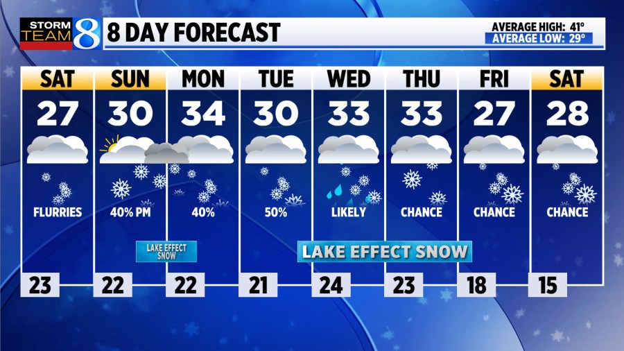
GRAND RAPIDS, Mich. (WOOD) — A break from the heavy lake-effect is expected Saturday, though cold temperatures will keep the winter feel around.
TODAY Cold with lake-effect flurries
LOW 23°
HIGH 27° (wind chill in the teens)
WIND WNW 10-20 mph
TODAY The lake-effect machine will fizzle to scattered flurries. Cloudy skies will persist, and it will be cold, with highs in the 20s and wind chills in the teens.
TONIGHT Flurry chances persist, with overcast conditions and lows in the low 20s.
SUNDAY Lake-effect is expected to intensify into the afternoon and evening, especially south and west of Grand Rapids. Several inches will be possible. Mostly cloudy skies will continue, with highs near 30 degrees.
MONDAY Heavy lake-effect snow will be possible in the morning, especially south and west of Grand Rapids. Cloudy skies once again, with highs in the low to mid 30s.
TUESDAY Lake-effect showers will be possible, with highs near 30.
LOOKING AHEAD Active, winter-like weather is expected through the end of next week, with another heavy round of lake-effect possible in the Wednesday – Friday timeframe.
Where is Matt Kirkwood? An update on our morning meteorologist