
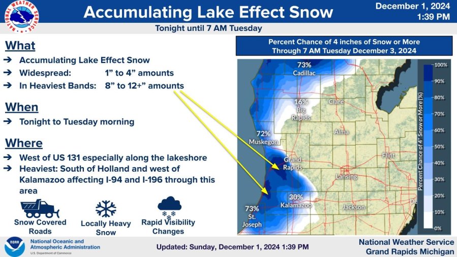
GRAND RAPIDS, Mich. (WOOD TV8) — The Winter Storm Warning and Winter Weather Advisory have expired. We still have some flurries, mainly from Grand Rapids to the south, but they are light and most main roads are in good shape.
We do have a new Winter Storm Watch for northwest Lower Michigan. It’ll be in effect from Manistee and Wexford (Cadillac) to the north. This is for 3-13″ of new snow along with wind gusts to 35-45 mph, which will cause blowing and drifting snow.
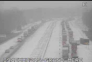
This was a late Monday morning pic. of I-94 in northern Berrien County near Benton Harbor. Moderate to heavy snow was falling. We had a couple reports of 2-3″ of snow falling in just one hour. Traffic was going slowly – in fact, nearly stopped going eastbound.
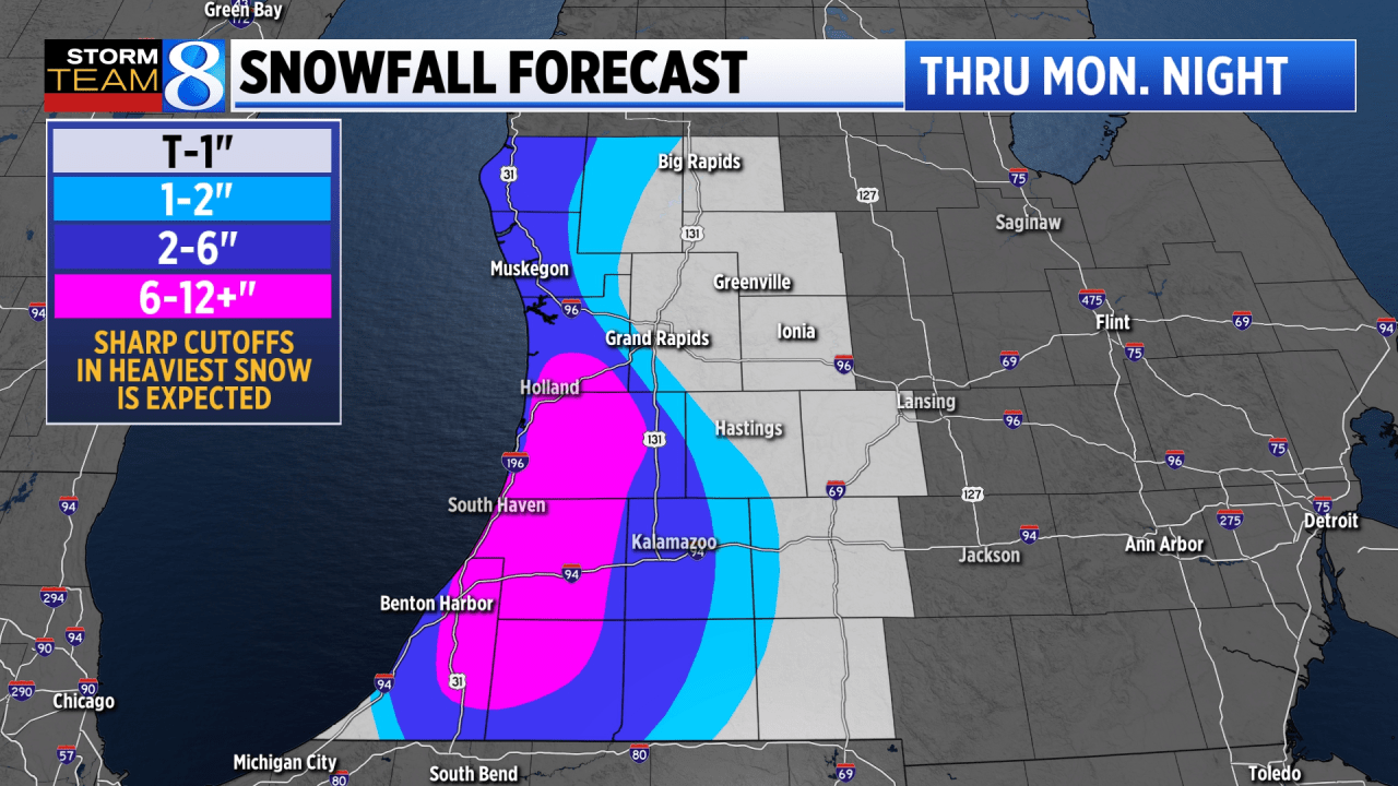
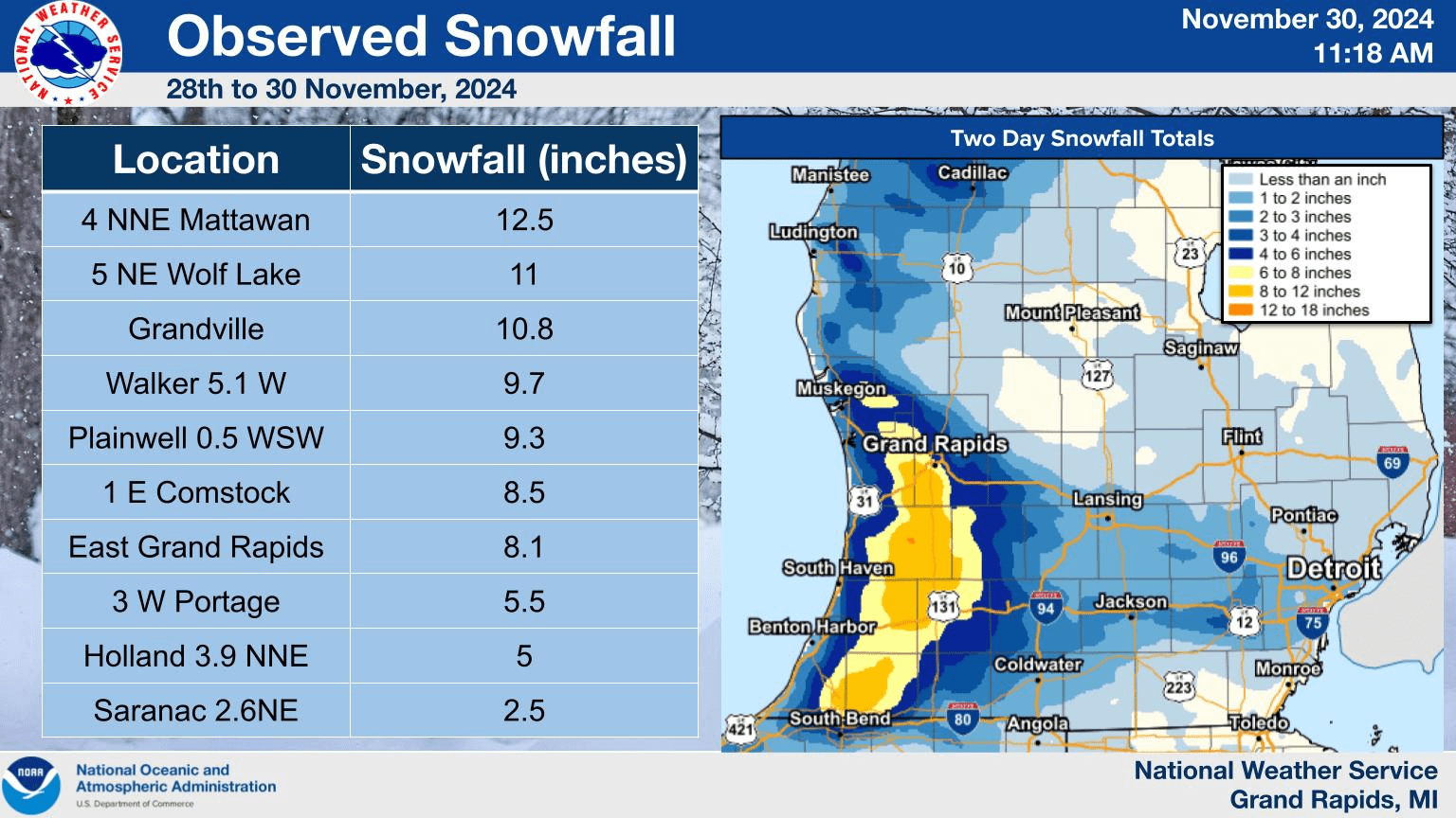
Snowfall totals of 12-14″ were reported in western Ottawa and western Allegan Counties. Port Sheldon had 12.5″, West Olive had 10″ with 7.5″ at Hartford. A foot of new snow fell at Bangor and South Haven and a foot of snow fell just south of Grand Haven. Up north, Darragh reported 13.4″ and a spot south of Kalkaska had 11″.
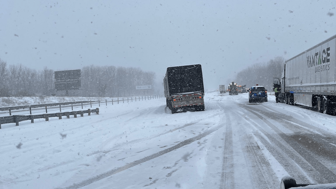
There was a multi-car accident on I-94 near Hartford. Fourteen passenger vehicles and 3 semis were involved. Plus there were 15 other slide-offs nearby, but not involved in the accident.
Check this out…4 day snowfall in Otsego County of 46.7“,
SNOW 2 N OTSEGO LAKE STATE P 44.95N 84.70W
12/02/2024 M46.7 INCH OTSEGO COUNTY MI NWS EMPLOYEE
4-DAY TOTAL ACCUMULATION FROM NWS EMPLOYEE.
They got M7.7" Monday - OTSEGO LAKE STATE PARK MI NWS EMPLOYEE
LOCATION: 6 MILES SSW GAYLORD. 24-HOUR
TOTAL AS OF 7PM DECEMBER 1ST. BRINGS EVENT
TOTAL TO 43.6 INCHES.
ELMIRA (also in Otsego Co.) reported a 4-day snowfall total of 46". Sault Ste. Marie had a snow depth of 25" as of early Tuesday (12/3).
Other snowfall totals were 11.5" at Kalkaska and 10.5" at Mancelona.
And check out these 4-day snowfall totals from upstate New York:
3 SW COPENHAGEN 65.9 IN
4 SW BARNES CORNERS 65.5 IN
FORT DRUM 63.0 IN
1 S COPENHAGEN 61.0 IN
CASSADAGA 54.2 IN
PERRYSBURG 53.7 IN
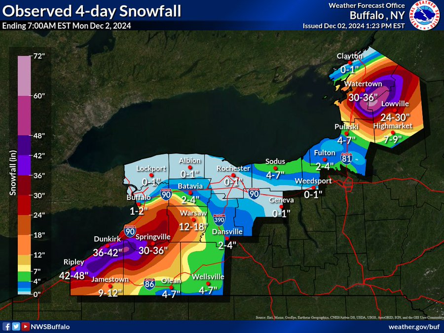
Quite a sharp cutoff in snow totals in the Buffalo area. The airport had just 1.2" of snowfall, while South Buffalo had 12.8" and Springville (same county) had 38.4".
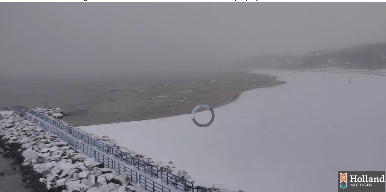
This is a late morning pic. from Holland State Park. At 11 o’clock, the water temperature of Lake Michigan at the Muskegon buoy was 47.6, quite a bit warmer than the air temperatures over the land (upper 20s to low 30s). There was surface convergence going on. The wind at Muskegon was north at 9 mph. The wind at South Haven was south at 6 mph and the wind at the Muskegon buoy was west. The air was rising along the lakeshore, helping to build up the clouds and snow.
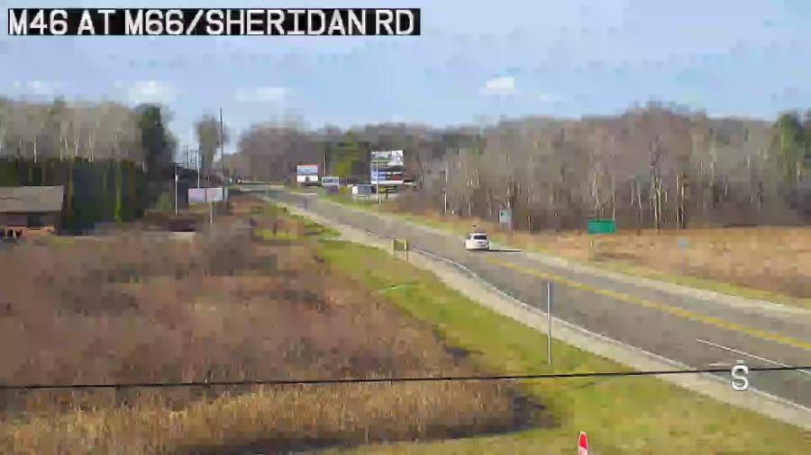
On the other hand, check out the webcam at 11:30 am at M-66 and M-46 near Edmore. The sun is shining and roads are clear.
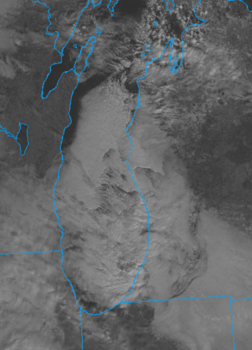
Here’s a mid-morning satellite picture – showing the mostly clear skies northeast of Kent County, across parts of northern Indiana and over in Wisconsin near Green Bay and also the clouds (snow) over West Michigan near Lake Michigan.
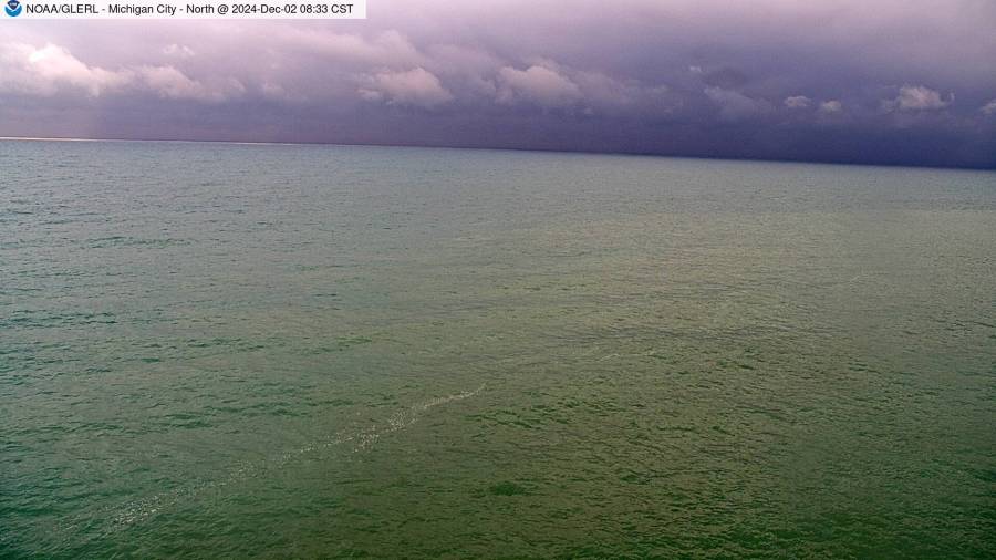
Here’s a late Monday morning picture from the lighthouse at Michigan City, Indiana. Here it’s dry, with the sun poking through from time to time…but looking northeast, you can see those ominous, dark clouds toward Benton Harbor where they are getting the heavy snow. The water has a green tint.
We had a report of a cloud-to-ground lightning bolt that hit along US 31 in Oceana Co. Monday morning.
Here’s a list of school closings and delays.
*****************************************************************************************************
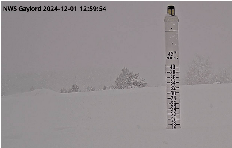
Friday was the snowiest single day EVER at the National Weather Service site 9 miles south-southwest of Gaylord in Lower Michigan. Here’s a pic. of the heavy snow and the snow stick showing around 17″ of snow on the ground. They had over 43″ of snow in 4 days.
SNOW ON THE GROUND (as of Sunday morning): 7 inches in Champion, 3 inches in Grand Rapids (airport), Muskegon and Kalamazoo, and 2 inches in Ionia, Fremont and Manistique. I’ll update this later this Sunday.
Periods of snow or snow flurries are possible Sunday with heavier snow in the lakeshore counties in the evening.
The temperatures should be below freezing for most of Monday, which means the snow may stick to untreated roads, and especially sidewalks, driveways, parking lots and lesser-traveled roads. Heavier snow showers can cause roads to ice up quickly. If you are driving, the road might be just wet and then you drive into a heavier snow band or an untreated section of roadway, the road gets slick quickly.
GALE WARNING FROM 1 AM WEDNESDAY TO 1 PM EST THURSDAY GUSTS COULD REACH 40 MPH.
Radar for Ottawa, Kent, Ionia and Montcalm Counties.

Southern Lower Michigan radar.

State of Michigan radar.

Midwest radar

National radar.
Here are current Michigan weather observations, a surface weather map and the latest Grand Rapids NWS Forecast Discussion.
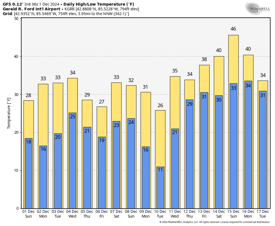
The cool weather pattern will continue into the 2nd week of December. Here are the forecast high and low temperatures from the Saturday night run of the GFS model. The model has it chilly through about Dec. 12 then temperatures rebound at least briefly back into the 40s by the middle of the month.
The average high temperature for this Sunday is 40 degrees, so the high temperatures of 28 degrees on Friday and 26 degrees on Saturday were significantly colder than average. Our average high temperature falls from 40 degrees on Sunday to 30 degrees for most of January, rebounding back only to 37 degrees by the end of February.
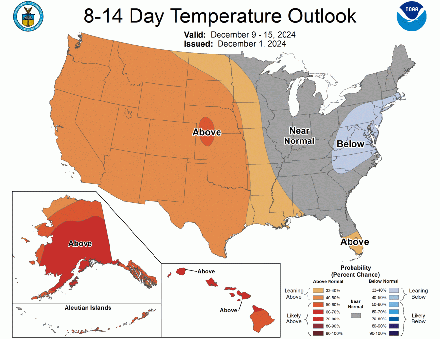
The latest 8-14 Day Temperature Outlook calls for temperatures to return to near average for December 9-15. This would likely mean colder than average for the first part of this 7-day period, then near to maybe even a touch warmer than average for the 12th-15th.
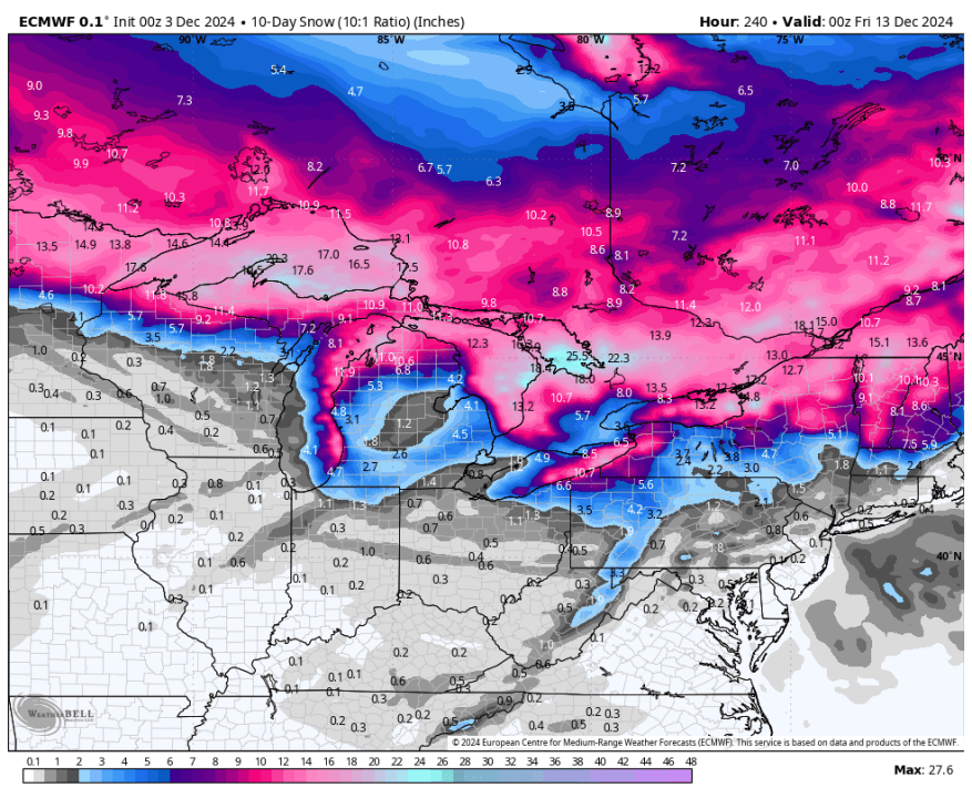
The map above is a forecast total snowfall over the next 10 days from the European model. Note the heaviest snow and the storm track is forecast to be along and north of the Canadian border.
Stay with Storm Team 8 for the latest forecast.
Ski Brule was the first ski resort in Michigan to open last week. They reported, “Olympic Gold Medalist Nick Baumgarter joined us at opening for the first chair.” Bittersweet, Boyne Mt. and Mt. Holly are also open. Many other resorts in Michigan will be open for the coming weekend.
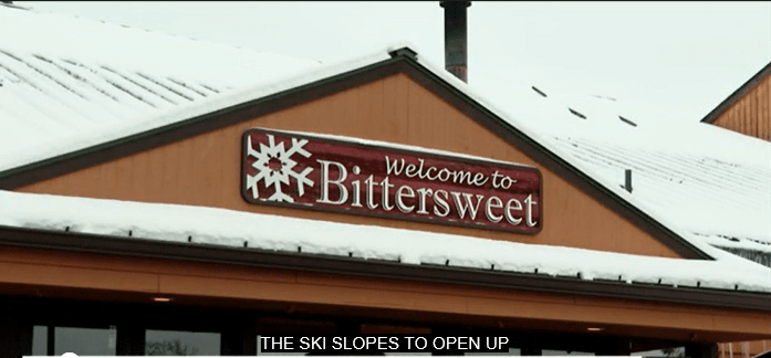
With lots of natural snow and near perfect snowmaking weather for the last 72 hours, Bittersweet Ski Area, west of Otsego opened on Monday (12/2).

*****************************************************************************************************
Up to 54 inches of lake-effect snow caused authorities to close I-90 from NE of Cleveland OH to near Buffalo NY: “Due to the lake effect snow storm and the closure of I-90 in PA from the NY State line to I-79, ALL VEHICLES were banned on the Thruway (I-90) …until further notice. People are reported to be stuck in their cars.” (graphic above from 11/29 – shows area that got the heaviest snowfall).

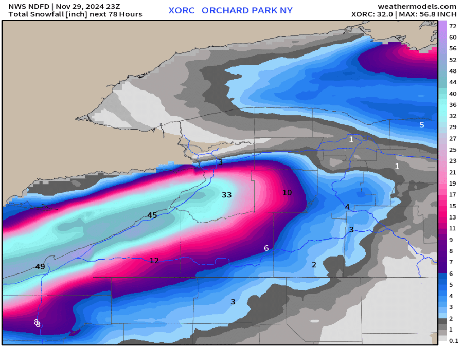
The heaviest lake-effect snow band off Lake Erie has stayed just south of Buffalo. The San Francisco 49ers/Buffalo Bills NFL game was played in the snow. Hundreds of volunteers came to shovel and push the snow out of the stands. Highmark Stadium is several miles south of the Buffalo Airport (BUF) and did received up to 24″ of snow, but much of the time, the heaviest snow was just to their south, where over 40″ of snow fell.
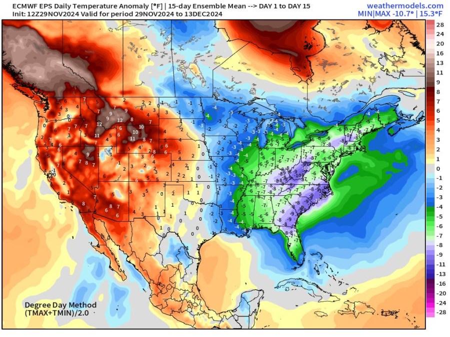
Here’s the forecast temperature anomaly (difference from the average) over the next 13 days. We’re forecast to be 3-6 degrees cooler than average in West Michigan. Note the general pattern — cooler than average in the eastern half of the U.S. and warmer than average in the West.
More snow is likely Tuesday night into Wednesday, mainly in northwest Lower Michigan, with snow showers on Thursday. There could be a drop of rain or drizzle, but it would transition to snow Wed. night. Grand Rapids has now had 4 consecutive days with temperatures below freezing. The record for that is 45 days back in the very cold winter of 1976-77.
Since Nov. 13, the most sunshine we have received on a given day is 31%. During that stretch, we’ve had 14 days with 10% or less sunshine.


