
Monday AM - Dec. 9
We had a high temperature of 50° in Grand Rapids on Sunday. That was 12 degrees warmer than the average daily high of 38°. It was the warmest day since Nov. 20. It was also the sunniest day since Nov. 26 with 60% sun (it was cloudier north of G.R. Because of the warmer weather, most of our snow has melted.
Today we have the earliest sunset of the year at 5:08 pm in Grand Rapids. The latest sunrise isn't until Jan. 3. The shortest day is Dec. 21, the Winter Solstice.
The clearing line is slowly working it's way across Lake Michigan/West Michigan as I type this. It's another warm day - 47 deg. at my house at 11:30 am.
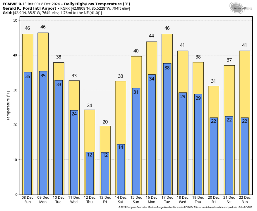
A blast of Arctic air moves thru from Tue. PM - Fri. AM and that will get the lake-effect snow going. The wind chill could be near zero Wed. night/Thu. However, the milder air is back with highs in the low 40s early next week.
The back-and-forth pattern between cold and warm, snow and thaw should continue into January.
***************************************************************************
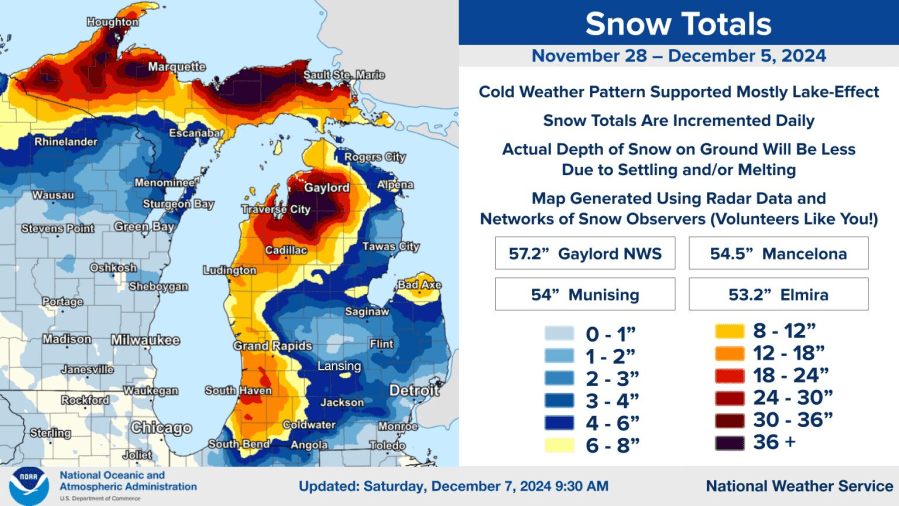
Here's a look at snowfall since Thanksgiving. You can see that the snow we have had has been mostly lake-effect, with cold west to northwest winds coming across the relatively warmer waters of the Great Lakes.
Thundersnow was reported at Muskegon, Holland, Grand Haven, Grand Rapids and a half dozen other communities Thursday evening. Here’s thundersnow in Middleville.
Peak wind gust at the South Haven Airport was reported at 74 mph! That’s hurricane force!
MUSKEGON       LGT SNOW  34  28  79 W32G53    29.43S VSB 1   WCI  20
SOUTH HAVEN    LGT SNOW  35  32  87 W24G74    29.52R WCI  23 TC   2

We were lucky we didn't have leaves on the trees, as many more of them would have come down in that wind.

Other peak gusts:  Saugatuck Beach 67 mph, St. Joseph 63 mph, Benton Harbor 61 mph, Whitehall 61 mph, Macatawa 59 mph, South Bend 58 mph, Douglas 57 mph, S. Haven Pier 56 mph, Grand Haven 54 mph, Casnovia 54 mph, Muskegon 53 mph, Ludington 52 mph, Holland 52 mph, New Era 51 mph, Zeeland 51 mph, New Era 51 mph, Hesperia 51 mph, Pentwater 49 mph, Grand Rapids 49 mph, Kalamazoo Airport 48 mph, Shelby 46 mph, Allegan 46 mph, Big Rapids 46 mph, Jackson 36 mph, Nunica 46 mph, Pullman 46 mph, Cedar Springs 45 mph, Alto 45 mph, Paw Paw 45 mph (snow rollers reported in Paw Paw.
The strong caused the heaviest snow to occur more inland toward US 131 than right at the immediate lakeshore.
Here’s forecast highs and lows from the European model. Temperatures warmed up during the night, peaking at 50 deg. in Muskegon and at least 45 deg. in Gr. Rapids – so our snow has been melting away.
It was also quite windy, with overnight wind gusts of 45 mph in Grand Rapids and 50 mph in Holland.
We get back into the Arctic Air later next week, especially Thursday and Friday, but after that it’s back to the mild pattern for the following week. If we get a white Christmas it’s going to have to come right before Christmas Day.
Magnitude 7.0 earthquake off the California coast. Tsunami warning issued for N. California and S. Oregon. Check out the earthquake stirring the water in a swimming pool.
******************************************************************************************************
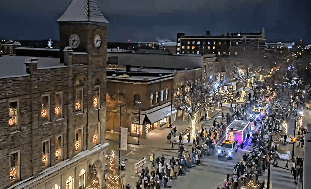
Here’s a pic. of the Holland Parade of Lights Tuesday evening. I rode in the parade. Literally thousands of people there – very pleasant and fun event.

Thursday night I did something I’ve never done before. I was a guest conductor for the Grand Rapids Symphony while they play the song “Sleigh Ride.” It was a blast! and I hope some of you will consider coming to see the Pops Concert. There are performances Saturday evening and Sunday afternoon. Here’s a link to check out tickets. You can pick your seats.

Saturday evening I was in the Grand Rapids Santa Claus Parade. Zillions of people downtown, looked like the peak Art Prize crowds. Lots of people said “hi” to me.


