
The top picture shows a 20-foot beam that a tornado tossed through a car windshield in south Oklahoma City. The car was not occupied at the time. Tornadoes, wind damage and large hail fell from thunderstorms in the Southern Plains from Saturday Nov. 1 – Tuesday Nov. 5 There were at least 14 storm-related injuries.
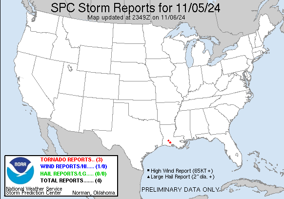
Here’s U.S. storm reports for Tuesday, Nov. 5. Not much, but there were several tornadoes in southern Louisiana. The twisters resulted in at least several injuries near Basile LA when a camper was rolled over. A business was heavily damaged and a number of trees and wires were knocked down.
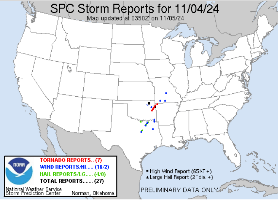
Here’s storm reports from Monday/Monday night (Nov. 4). Seven tornadoes were reported in eastern Oklahoma and northwest Arkansas. Structural damage was reported, along with downed trees and wires. It looks like all the tornadoes may have come from one supercell.
EF3 damage was confirmed with 3 different tornadoes and EF1 damage with two other tornadoes.
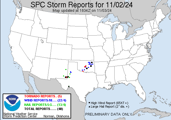
There were at least 6 injuries reported in southern Oklahoma City Saturday night, according to the Oklahoma City Police Department. All were non-life-threatening. Five of the injuries happened near SE 89th & Sooner Rd. according to police. The tornadoes occurred in the middle of the night when it was dark.
This map shows storm reports from Saturday and Saturday night (Nov. 2). Each red dot on the map is a tornado report, each blue dot represents wind damage and each green dot is a severe hail report.
The Storm Prediction Center has confirmed 5 tornadoes during this period. These were confirmed by video, pictures, storm spotters or a tornado debris signature on radar.
There were 22 reports of wind damage, including a 92 mph gust at Halfway OK. The largest hail reported was 3″ in diameter near Eunice NM.
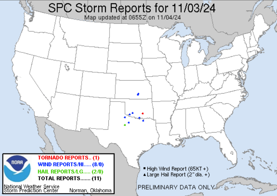
Sunday/Sunday night (Nov. 3), there was one tornado near Stonewall OK. There were 8 reports of wind damage, including a flipped semi truck near Marietta OK. Large hail fell at Anson TX.
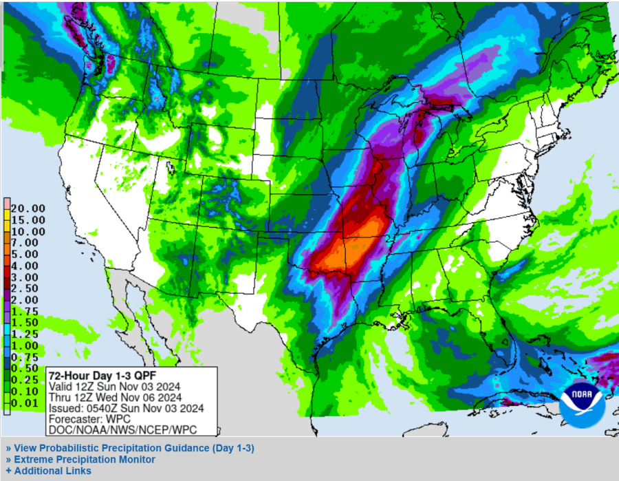
The above map was the rainfall forecast for the first week of November.
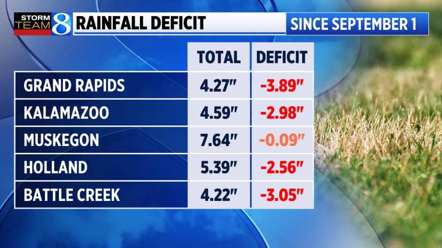
We had 1-2″ of rain over much of West Michigan. We needed the rain. The graphic above shows rainfall from Sept. 1 – Nov. 5. The system that produced our rain from mainly on Tuesday has moved out of the area leaving us with dry conditions this Thursday and Friday.
Since September 1 – November 3, Grand Rapids had just 2.62″ of rain. The average rainfall for that period is 7.69″, so that put us 5.07″ below average. The water level of Lake Michigan has dropped 7″ in just the last month, because of the dry conditions.


